Tuesday, May 23, 2017

Sweeney Creek--ATV

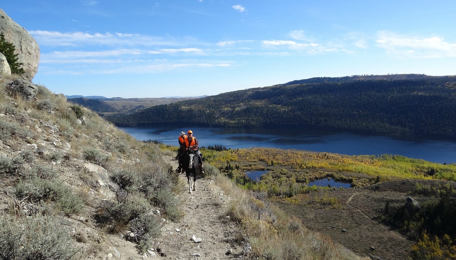
May 2018 update!  Most of the trail is like this.

  It's only a 17 minute drive to the trailhead from Pinedale and NO dirt roads involved.  It has Sweeney Creek as a water feature, although no crossing required on this portion. We shared the trail with a couple of hikers in May, but the only ATVs we saw were during hunting season in October. In June, 2017, extensive rock blasting and road grading was going on.  There were numerous sharp rocks, but most were avoidable.  Google Map "Sweeney Creek" for directions. This post is about the "North Sweeney Creek ATV Trail". (Even though it goes along the actual Sweeney Creek.  Not to be confused with the "Sweeney Creek Pack Trail" which goes up another drainage.)  At .79 miles in on the doubletrack, the trails separate.  Keep to the right for the Grouse Mountain/Half Moon Ridge/Sweeney Creek Pack portion. See the separate post on that.  Keep to the left for the North Sweeney Creek. We avoided this trail in 2019 because of the extensive deforestation and rocky road.    

(Click on any photo for enlarged image.  Some photos courtesy of Teisha Preece)


Parking area. The first is graveled and graded with a great view of Half Moon Lake.  It is called the "Half Moon Overlook" trailhead.  The 2nd area has been used for parking in the past, but as of August, 2017 has been "rocked" off. I have seen horse trailers parked there, but best to use the first area. The pink line is a rocky trail from the parking lot.  The blue line is a "short cut" along the road.  

Our track on May 22, 2017.  7.66 miles.  Elevation= 7,979' to 8,468'.  Trail conditions:  90% dirt doubletrack with about 60% of that somewhat rocky.       This track went up the North trail, then back to the turn off to the Ridge trail.  Downfall blocked any further progress on that trail at that time.  It was cleared later in the season. 

 Parking area with the view of Half Moon.

  Parking area, room for many rigs with plenty of turn around space.  No rest room.

 There are still some rocky spots like this.  A barefoot horse in reasonably good condition will have no problem.  Not nearly as much snow as in 2017.  Photo taken May 16, 2018.


Off the path in the forest. May 22, 2017


Place where snow covered the trail May 22, 2017.


Much of the trail looks like this.


And some parts are like this.


Some of the trail is like this, but thankfully not much.


May 27, 2017, still snow in many spots.

Off the path, May 22, 2017


This is the North "trail" higher up on June 20, 2017. This is just past the boundary where motorized vehicles are not allowed.  At least the snow was gone.


The beautiful meadow we stopped at June 20, 2017.  This area is probably the most gorgeous of the North Sweeney Creek portion.   A big change from the May rides. The flies and mosquitoes were bothersome, but not too bad.


June 20, 2017, Sweeney Creek by the meadow in the photo above.


No snow left anywhere on the North Trail, June 20.


On the Sweeney-Kelly Park connector trail, July 14, 2018.  Refer to Kelly Park for more information on this.


Friday, May 12, 2017

LIttle Soda Lake


 It has everything...forests, sage, water features, meadows, wildflowers, mountain vistas. See the post on Lowline-Spring Creek Park  and Chambers Bay for more trail options from the same trailhead.  Be aware there are cattle milling about from June through September. 

(click on any photo for enlarged images.  Some photos courtesy of Teisha Preece)

Little Soda Lake, May 10, 2017

Directions from Pinedale.  It's about 7 miles on a dirt/gravel road. This route from Google shows driving all the way to Little Soda.  Between the trailhead and Little Soda Lake is really only suitable for 4 wheelers. Don't attempt driving it with a trailer.  Ride it instead.  Keep in mind that Soda Lake is a protected wildlife Habitat area and not open to the public until May 1.
This is a herd of draft horses by Soda Lake.  You may pass them on your drive in.  They are used in the winter to pull sleds to feed the elk herd that winters here.  This area is owned and managed by Wyoming Fish and Game.


The lower circle is where we have parked in the past. (We call it #2)  It is now a camp spot with a cement fire grate. We still park there if it's empty.  The upper circle is the usual place to park. (We call it #3)  There is a "turn around" before the gate where up to three rigs can park. There is also plenty of room to park just inside the cattle guard if the gate is open and no one has commandeered it for a camp spot.  
This is a parking spot just before #2.  It is also a campspot. Call it #1. 
This track was done on May 10, 2017.  About 7.2 miles.  Min. altitude=7,507'; Max. altitude=7,802';  Trail conditions were muddy and some snow, but also much dry ground.  30% rocky, 70% dirt, grass.  


This is NOT Little Soda, but a "pond" named "Mud Lake".


Mud Lake...still a nice water feature, May 10

A view of Mud Lake on July 22, 2017
Mud Lake, May 20, 2020
Meadow just before Little Soda Lake, May 20, 2020

There was some snow on May 10, 2017


Spectacular view of Fremont Lake, May 10


One of the water features on May 10, 2017 that disappeared later in the season.  This is also a landmark (the aspens) where the trails separate.  One goes to Chambers Bay (straight up) and the other the Lowline Trail (to the left.)


Another water feature that we had to ride right through on May 10.
One of the "mini meadows".  This particular one was knee deep in water in May, 2017, but was clear in July.  I named it "Dead Elk Meadow".
Little Soda Lake, May 13, 2019

Heading back by Mud Lake after seeing Little Soda Lake.


Another view of Fremont Lake from a little lower location.


Little No Name pond on the way to the east side of Little Soda.


View of Little Soda from the east side.

(Update:  May 22, 2019-The Fremont Ridge and connector portion of that trail system has been "unofficially" cleared.This part is not an "official" trail that the Forest Service wants maintained.   However, I will give one landmark hint---"Little Carved Bear".)


The track above begins at #2 (or #1) park spot and goes on the Fremont Ridge portion, loops back by Little Soda and Mud Lake and back up.  A really nice loop.


May 13, 2019, still some snow.

Aspens just budding...May 20, 2020
Entering the "Black Forest"  May 20, 2020


The photos below show the boundary fence/gate just out of parking spot #1.   The first is the "old" barb wire gate.  The next one was taken in September, 2019 just after the "new" bright, shiny green gate was installed.