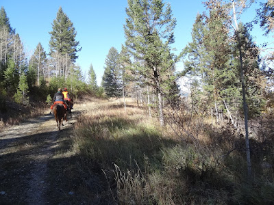
 This area of trails is about 1.3 hours from Pinedale. It is almost to Hoback Junction, which puts it closer to Jackson. It was worth going once, but don't think we'll do it again. The constant rocks (of the small ouchy kind) were hard on our barefoot horses even with boots on. However, there is gorgeous scenery, one water feature (Adams Creek) and mountain vistas. The elevation is lower than most trails around Pinedale. Even though we were riding in mid-October, there was no snow.
There is a "challenging" part that Nancy called the "Dipsy Doodle". There was a landslide a few years ago and it caused some interesting terrain. I didn't get photos of it. A guide is recommended because there are many trail options, some of which may not be good choices. Run a Google map search for "Bryan Flat". It is off of Highway 191 west of Hoback Junction.
(click on any photo for enlarged images.)
 |
| Getting from the highway to the trailhead. |
 |
| Looking towards the parking area from Hwy 191. |
 |
| Total mileage: almost 10; Elevation=6,158-7228'; Ascent/descent=1,650' Trail conditions= 20% dirt, 70% somewhat rocky, 10% really rocky. |
 |
| Just starting out. Hard to know which way to take. Thus, the need for a guide the first time. |
 |
| Much of the ride is on a doubletrack. Check out that interesting tall Alpine Fir. |
 |
| Sometimes the "track" disappears. |
 |
| Just heading into the "Dipsy Doodle". |
 |
| Lunch spot along Adams Creek. |
 |
| Crossing Adams Creek on our way out. Photo courtesy of Nancy Stephens. |
 |
| One of the trail intersections. The Teton mountain range is visible in the distance. |
 |
| Interesting uprooted tree trunk. |


No comments:
Post a Comment