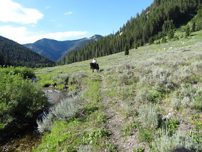
A good ride in the Wyoming Range if you are ever horse camping in the McDougal Gap area. (see that post). I doubt we'll ride this one again, but it was worth doing once. It eventually connects with the Wyoming Recreation Trail (6 miles). We only rode up about 3.5 miles until the trail got too steep and rocky. There is a nice water feature, mountain vistas, wildflowers, sage benches, evergreens. The best part of the ride was a side trail we took and viewed the aftermath of a huge avalanche.
(Some photos by Teisha Preece. As usual, click on any photo to open enlarged image views.)
 |
| Just before the turn off to the trailhead. It is approximately 5 miles beyond the McDougal Gap trailhead. |
 |
| The turn off is un-marked with about .2 mile to reach parking area. |
 |
| Our track on August 10, 2019. A little over 7 miles round trip. Min. Altitude=7,201'; Maximum Altitude=8,025'. Ascent/Descent =1,400'. Trail conditions=85% moderately rocky with numerous small sharp rocks that horses hate. Luckily there were many softer places off trail. 15% dirt/grass. Shoes or boots recommended unless your horse is SUPER good barefoot. The Yellow arrow shows the location of what we named "Avalanche Gulch." |
 |
| View of the parking area coming off the trail. There is room for 2 rigs, maybe more if the two RVs weren't there. Not much turnaround space. |
 |
| Typical of much of the trail. |
 |
| This meadow is as far as we got. Beautiful stream there. Lots of wildflowers and horse-mint. |
 |
| North Sheep Creek... |
 |
| One of the creek crossings. |
 |
| Another stream crossing. This is the place where we took the side trail to Avalanche Gulch. |
 |
| Riding up Avalanche Gulch. The "trail" is barely there and disappears in places. |
 |
| This must have been quite the avalanche! |
 |
| Wow...the dramatic forces of nature. |
 |
| This is a photo I found on the internet of the area we rode in. |


No comments:
Post a Comment