Here are shown photos of both the Lowline Trail (which is used to access Glimpse Lake. I realize there is ANOTHER "Lowline" trail by Scab Creek. They're quite a ways apart. In the future, they will be referred to as Lowline-Soda and Lowline-Scab.) AND a very small portion of the Spring Creek Park Trail. Refer also to that post. More photos will be added as we ride further.
(click on any photo for enlarged images. Many of the photos courtesy of Teisha Preece)
UPDATE!
 |
| This is our track on June 26, 2019. The RED arrow shows the intersection of the trails. Take the left one to Spring Creek Park and the middle one to Summit Lake and Chambers Bay. The Right trail is a dead end. (As of Sept. 4, 2019, the trail has been cleared all the way to Spring creek park.) On our way back we took the alternate trail to the east, which was fine until we reached the "big swamp" at the pink arrow. Water looked about 2 feet deep, but we didn't want to risk it with unsure footing underneath. We creatively bush whacked our way around the swamp and back to the trail. (As of September 7, 2019 that "big swamp" is no longer there. ) |
 |
| Here is a close up of the trail intersection at 1.7 miles in. |

|
Go through a gate and head north from the trailhead parking. You CAN park just over the cattle guard to avoid the gate. At first it is just open sagebrush.
Track taken on June 5, 2017. Total mileage: 10 miles. Elevation=7,507-8,638' Ascent/descent=1,300' Trail conditions: Lowline Trail is Dirt and grass=80%, Somewhat Rocky=15%, Quite rocky=5%; Some deadfall, but passable. Barefoot horses in good condition can handle it fine. The Spring Creek Park Trail on top the ridge is 50% dirt and 50% rocky, not so great for barefoot. Big rocks and those little ouchy ones.
|
 |
| Then a gradual turn to the right and it opens into grassy areas along a fenceline. This portion of the trail was really boggy and muddy on June 5, 2017 and again on June 26, 2019. |
 |
| Riding along the fence line up the Lowline. |
 |
| Up some hillsides on the Lowline trail. |
 |
| Small No-name lake. (which I have since dubbed "Little Duck Lake", because almost every time I see little ducks on it.) |
 |
| Then past an even smaller pond. |
 |
| Lots of meadows. |

 |
| Aspen groves.... |
 |
| Some small water features. This one dries up later in the season. |
 |
| View down into Spring Creek Park. A trail heads down that way, too. |
 |
Where the Spring Creek Park Trail heads up from the Lowline. There is a sign that says "Trail". It is also called the "Glimpse Lake" trail on some maps.
|
 |
| Heading up the Trail. |
 |
| Also heading up the Spring Creek Park Trail. |
 |
| View of Willow Lake from the Trail. |
 |
| Wow Factor looking at the Winds and Fremont Lake |
 |
| Again the Wow Factor increases. |
 |
| Looking at the Wind River Mountains. We think the lake is part of Long Lake. |
 |
| More of the Spring Creek Park Trail |
 |
| And still More... |
 |
| And still more |
 |
| And more of the gorgeous trail. |
 |
| The fabulous forest just does not stop... |
 |
| View of Fremont Lake |
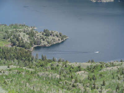 |
| A zoom view of Fremont Lake. There happened to be one boat on the lake. |
 |
| Spring Creek Park Trail on top of the ridge looking south. |
 |
| Much of the Trail is rocky like this. |
 |
| Lots of forest like this. |
 |
| We encountered a few snow patches on June 7. |
 |
| Heading back down the Lowline. Beautiful view of Soda Lake. |
 |
| One of my favorite parts of the Lowline trail. Sigh..... |
 |
| This is a critical junction coming down onto the Lowline Trail. The correct path coming up from Soda Lake is the trail on the left. The one on the right comes up from Spring Creek Trailhead. (Yes, it's shorter, but I would not drive a horse trailer on it. Many people have. High clearance is necessary.) |
 |
| Heading out on the lower part of the Lowline. |
 |
| This IS Bear Country. Stay noisy and watchful. |
 Some spectacular trails accessible from the same trailhead as Little Soda Lake


No comments:
Post a Comment