 Horse Creek is in the Wyoming Range, rather than the Wind Rivers. Of the trails accessible from the Horse Creek road, this is my favorite so far.The scenery is spectacular. The view in the photo above is of South Horse Creek. Although, there are no lakes per say, there are numerous water features (springs, creeks, beaver dams), stunning evergreen forests, expansive lush meadows, mountain views and the trail is BAREFOOT friendly. There are a few rocky places, but nothing a horse in reasonable condition can't handle barefoot. There is no way photos can do this ride justice. (Update: As of August 15, 2018, we were only able to get less than a mile past the hunter's camp when we encountered impassable deadfall. Personally, I'd rather not ride here until it is better cleared, perhaps closer to hunting season. This shortened ride is not worth the drive. (Also, the dirt/gravel road is in bad condition, worse than 2017. Many potholes and washboard. Average speed around 18 miles MPH. Some places 8 MPH and some 30 MPH.)
(remember click on any photo for enlarged images. Thanks to Teisha Preece for some of the photos)
 |
This is the general direction from Pinedale. To the trailhead it is about an hour from our place.
 |
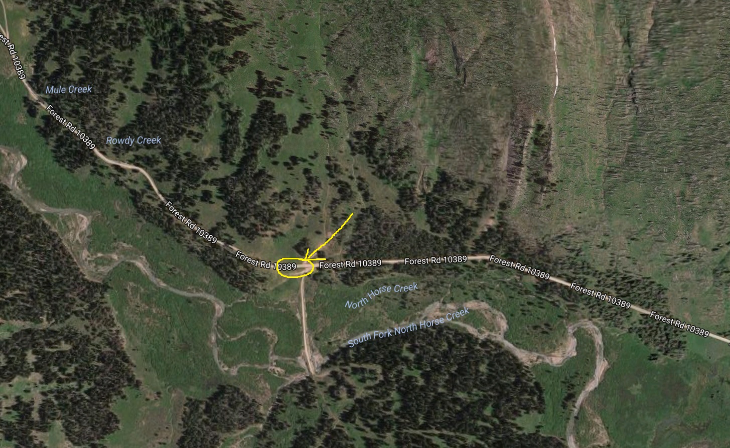
| Showing parking areas. These are 7.8 miles in from where the pavement ends. |
|
 |
| GPS track. About 11.5 miles out and back. Elevation: 8,107-8,694'; Ascent/descent=1,800'; Trail conditions=25% somewhat rocky; 75% dirt/grass. |
 |
| One of the parking areas--room for about 6 rigs. |
 |
| Starting out. Right in the center of this photo shows the trail. |
 |
| At about 1.2 miles in, there is turn off left. A single track trail leaves the doubletrack. You can stay on the doubletrack, but it won't take you on the best ride (the one in these photos). |
 |
| Heading into the expansive high meadow. This photo was in September. In late July, the meadows are COVERED in wildflowers of every kind. |
 |
| After traversing the meadow, Notice the hunting camp in the middle right. The stream CAN be crossed heading towards it, but we found a better crossing at the red arrow. Ride left of the two trees. There is also an even better crossing at the far right of the camp. |


 |
| There are some hoodoos at about 4.5 miles in. Nothing like what's in Utah, but interesting nonetheless. You have to be on the lookout on the right or you might miss them. |
 |
| Keep to the right at this intersection. |
 |
| View of Mt. McDougal and Gunsight Pass |
 |
| Nice lunch spot on the stream at about 5.7 miles in. The trail goes further up the ridge and eventually connects with the Wyoming Recreation trail, but that's too far for us on a day ride. |
 |
| This is the stream crossing back into the meadow. Just this side of the tree. |
 |
| One of the beautiful water features. |
 |
| Almost through. The parking area and our trailers are in sight. Yes, you might encounter cattle. |
 Horse Creek is in the Wyoming Range, rather than the Wind Rivers. Of the trails accessible from the Horse Creek road, this is my favorite so far.The scenery is spectacular. The view in the photo above is of South Horse Creek. Although, there are no lakes per say, there are numerous water features (springs, creeks, beaver dams), stunning evergreen forests, expansive lush meadows, mountain views and the trail is BAREFOOT friendly. There are a few rocky places, but nothing a horse in reasonable condition can't handle barefoot. There is no way photos can do this ride justice. (Update: As of August 15, 2018, we were only able to get less than a mile past the hunter's camp when we encountered impassable deadfall. Personally, I'd rather not ride here until it is better cleared, perhaps closer to hunting season. This shortened ride is not worth the drive. (Also, the dirt/gravel road is in bad condition, worse than 2017. Many potholes and washboard. Average speed around 18 miles MPH. Some places 8 MPH and some 30 MPH.)


No comments:
Post a Comment