Monday, June 12, 2017

Kelly Park


These nice trails are right near Sweeney Creek.  See that post for more information.  There are water features, sagebrush hills, wildflowers, meadows, grand forests and lots of grass and soft dirt.  Mostly great for barefoot horses. Kelly Park is a well known mecca for cross country skiing and snow shoeing in the winter.  There are places at the beginning of the doubletrack to pull off for dispersed camping.   (UPDATE: The road has been "re-done" in order that logging trucks can carry out long logs.  As of May 15, 2020, the road has been cleared of many rocks and is very rideable.) 
(Click on any photo to see enlarged images.)


Kelly Park parking area.  Right off the paved road and 20 minutes from Pinedale.

Paved Kelly Park parking area.  Room for about 4 rigs.


This was our track on May 30, 2017.  We parked at Sweeney Creek trailhead, hoping to connect to Kelly Park and cross the road.  However, the intermittent Surveyor Creek was too deep and swampy to cross over at the Kelly Park trailhead. We wandered through the forest, doing some serious bushwhacking ending up on some forest service roads. Total ride was about 6 miles.  (Update By late August the creek has usually dried up.) Much of the forest on the west side is/has been being cleared for logging.)   
This was our track on July 18, 2019.  About 5 miles up and back.


Sweeney Creek Parking area.  The right hand circled area is now discouraged for parking.


Looking back on the Sweeney Creek parking area.


This is the Surveyor Creek that was too high to cross safely on May 30, 2017. Update:  As of September, 2018, that creek has completely dried up.


Most of the riding was on soft dirt like this.


Some majestic lodgepole pines.
This is heading out on the graded forest service road.  It was quite hard and gravelly. We avoided it when possible.


Headed back to the Sweeney trailhead and a crossing over the intermittent creek.   


On June 10, 2017 we parked at Kelly Park Trailhead and explored some of those trails.  About 7 miles of fantastic riding.
Riding just above the Kelly Park double track.  Wildflowers galore!


The double track ends up in a meadow.  On June 10, 2017 it was boggy and wet all over.
This is the same area as the above photo, but taken on July 18, 2019.  Lots of logging going on.


This is Kelly Park Meadow right where the Fortification trail joins it. We were stopped by deadfall as we attempted Fortification in 2017.  As of September, 2018, it has been cleared.  As of July, 2019, there are areas of recent deadfall, but nothing you can't get around.

 The following photos are of the "Fortification Trail" which heads out from Kelly Park meadow to the top of Fortification Mountain.


Look for this sign for the connector trail to Elkhart Park and to the top of the ridge.


Heading up a steeper part of the Fortification trail.
Considerable logging, July 18, 2019.


Newly done road, July 18, 2019.


Boggy, but Wow on the wildflowers! June, 2017.


Much of the doubletrack looked like this in June, 2017.


...and this.


That's Fremont Lake in the far distance.


Some fun trail markers.


The trail wound back to a creek and the paved road about 1.5 miles from where we parked.  Approximately in the middle of this photo is a place where the small stream can be crossed to access the "White Pine" portion of the trail.  See the photos at the bottom of this post. 


Beautiful color, September 30, 2017


The meadow on September 30, 2017.  Still a few soggy spots, but "looks" dry.


Look at that long grass!  September 30.


The track above is one we rode on August 1, 2018. We rode out from Sweeney Creek parking area west of the road, then bushwhacked up to the forested area and wound our way north almost to the ski area, then back through Kelly Park on the  Sweeney connector trail.  Total mileage=7.65.  Would NOT recommend riding the west portion because of the forest decimation going on.  See photo below.


This is the stream crossing (Surveyor Creek) looking east.


Heading north on the double track towards White Pine ski resort.
Heading north on the double track towards White Pine ski resort


Heading north on the double track towards White Pine ski resort. You can see it in the distance.


Looking east.  Lots of grass and water features.


Heading south back to the parking area.  Note the piles of branch cuttings scheduled for burning later in the season.

The following photos were taken on October 5, 2018.  This is a good place to ride if the higher elevations are snowed in.


Even still more logging going on.  August 16, 2019.
A nice side trip from Kelly Park is the Connector Trail to Sweeney Creek.
This is the sign showing where to access the connector trail.  It is about a mile up from the trailhead.


Trail up to the Connector.  


The connector trail to Sweeney Creek.

Wednesday, June 7, 2017

Lowline and Spring Creek Park Trails


Some spectacular trails accessible from the same trailhead as Little Soda Lake
Here are shown photos of both the Lowline Trail (which is used to access Glimpse Lake.  I realize there is ANOTHER "Lowline" trail by Scab Creek.  They're quite a ways apart. In the future, they will be referred to as Lowline-Soda and Lowline-Scab.) AND a very small portion of the Spring Creek Park Trail.  Refer also to that post. More photos will be added as we ride further.
(click on any photo for enlarged images. Many of the photos courtesy of Teisha Preece)


UPDATE!  
This is our track on June 26, 2019.  The RED arrow shows the intersection of the trails.  Take the left one to Spring Creek Park and the middle one to Summit Lake and Chambers Bay.  The Right trail is a dead end.  (As of Sept. 4, 2019, the trail has been cleared all the way to Spring creek park.)  On our way back we took the alternate trail to the east, which was fine until we reached the "big swamp" at the pink arrow.  Water looked about 2 feet deep, but we didn't want to risk it with unsure footing underneath.  We creatively bush whacked our way around the swamp and back to the trail.  (As of September 7, 2019 that "big swamp" is no longer there. )  


Here is a close up of the trail intersection at 1.7 miles in.


Go through a gate and head north from the trailhead parking. You CAN park just over the cattle guard to avoid the gate.  At first it is just open sagebrush.


Track taken on June 5, 2017.  Total mileage: 10 miles.  Elevation=7,507-8,638'  Ascent/descent=1,300'  Trail conditions:  Lowline Trail is Dirt and grass=80%,  Somewhat Rocky=15%, Quite rocky=5%;  Some deadfall, but passable.   Barefoot horses in good condition can handle it fine.  The Spring Creek Park Trail on top the ridge is 50% dirt and 50% rocky, not so great for barefoot.  Big rocks and those little ouchy ones.


Then a gradual turn to the right and it opens into grassy areas along a fenceline.  This portion of the trail was really boggy and muddy on June 5, 2017 and again on June 26, 2019.
Riding along the fence line up the Lowline.


Up some hillsides on the Lowline trail.  


Small No-name lake. (which I have since dubbed "Little Duck Lake", because almost every time I see little ducks on it.)


Then past an even smaller pond.


Lots of meadows.
 
Aspen groves....


Some small water features.  This one dries up later in the season.


 View down into Spring Creek Park.  A trail heads down that way, too.

  Where the Spring Creek Park Trail heads up from the Lowline.  There is a sign that says "Trail".  It is also called the "Glimpse Lake" trail on some maps.

  Heading up the Trail.


Also heading up the Spring Creek Park Trail.
 View of Willow Lake from the Trail.
Wow Factor looking at the Winds and Fremont Lake


Again the Wow Factor increases.
Looking at the Wind River Mountains.  We think the lake is part of Long Lake.


More of the Spring Creek Park Trail


And still More...


And still more

And more of the gorgeous trail.


The fabulous forest just does not stop...


View of Fremont Lake


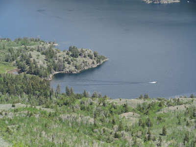
A zoom view of Fremont Lake.  There happened to be one boat on the lake.
Spring Creek Park Trail on top of the ridge looking south.


Much of the Trail is rocky like this.


Lots of forest like this.


We encountered a few snow patches on June 7.


Heading back down the Lowline.  Beautiful view of Soda Lake.


One of my favorite parts of the Lowline trail.  Sigh.....


This is a critical junction coming down onto the Lowline Trail.  The correct path coming up from Soda Lake is the trail on the left.  The one on the right comes up from Spring Creek Trailhead. (Yes, it's shorter, but I would not drive a horse trailer on it.  Many people have.  High clearance is necessary.)


Heading out on the lower part of the Lowline.


This IS Bear Country.  Stay noisy and watchful.