Sunday, December 24, 2017

South Cottonwood Creek

A pleasant ride in the Wyoming Range.  Worth doing once, but I doubt we'll go back.  Mostly because of the "terrible" rocky road on the drive in.  There are other rides closer and just as beautiful, but without that stretch of road.  It does have lakes/ponds, streams, stunning forests and gorgeous mountain vistas. 

(Click on any photo for enlarged images.)
Here are directions from Pinedale.  It is about 1.5 hrs to the parking area.  This is the same route in, if we were going to MacDougal Gap, but take the left fork just before entering the canyon. (Yellow circle) It is Forest Service Road 10050. DON'T google "South Cottonwood" as you'll get a completely different road. 
"Triple Peaks" on the way in.


Road after we turned left before the canyon.  It doesn't "look" too bad here, but gets worse.
Another "Soda Lake" passed on the way in.
Track on October 11, 2017.  We drove as far up the road as we could and found a place to park somewhere near the sign in the photo below.  Total mileage=8.5; Elevation: 8,350 - 9,026'; Ascent/descent=800'; Trail conditions: 15% dirt/gravel road; 10% very rocky; 20% somewhat rocky and 55% dirt/grass.  We encountered patches of snow in the shady areas.


This is one of the reasons we couldn't drive further in.


One of the really rocky areas.


One of the stream crossings.


A few rocky areas like this.


Hunter's camp where we stopped for lunch and then turned back.  We were told the trail after this gets steep and/or disappears.  It connects with the Wyoming Recreation Trail somewhere "up there".


On our way back.


One of the little lakes on the way in/out.  We kept to the right on the way in and took the other route on the way out.  Beautiful scenery in this area.


Friday, December 22, 2017

Tripod Hill

This ride goes out from the same parking area as Chall Creek.  It can be done when there is snow in the higher elevations. We rode it October 19.  Vistas of three mountain ranges from "Tripod Hill".  Mostly wide open with a little bit of forest. Options of extending the ride into the surrounding areas.  Could combine with the Chall Creek loop for a longer ride.  (UPDATE:  These photos were taken before the Roosevelt fire.  Not sure of what the area looks like now after the fire.)

(click on any image for enlarged images.)


Track on October 19, 2017; Total mileage=8.5; Elevation=7,877-8,294';Trail conditions:  Mostly soft dirt/grass, some slightly rocky areas.  Barefoot horses should have no problem.  Orange arrow is Tripod Hill.  Yellow arrow is parking area.


One gate open/close.


Thursday, December 21, 2017

Chall Creek

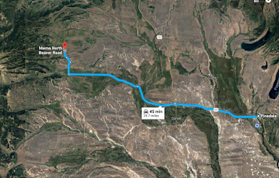
Another ride in the foothills of the Wyoming Range.  Accessed from the Merna North Beaver Road.  A pleasant ride with sagebrush hills, forests, meadows, a couple of small water features and some vistas of the mountains. Recommend a guide so that the correct turn offs are taken.  We encountered cattle when we rode here in August.  (UPDATE:  AS OF SEPT. 29, 2018,  from what I can tell from the Roosevelt fire maps, about 95% of the areas in the photos on this post have been burned.)

(Click on any photo for enlarged images.)


Approximate directions from Pinedale.

The parking area is a clearing on the left side of the road just into the Forest Service Boundary.


We rode this on August 28, 2017. Mileage=10.5; Elevation=7,877-8,701';  Ascent/descent=1,030'  Trail conditions: Some rocky, gravelly roads. The worst parts were on the upper portion on the left side of the track photo.  Beautiful scenery, but the rocky forest service road caused a struggle for our barefoot horses.  Boots next time!  About 60% dirt on the rest of the trail.  The portion circled in Yellow could be ridden as about an 8 mile loop.

This track started out on a slightly gravelly road for about a mile.

Just off of the "loop" winding our way up to the forest service road.


View of Hoback Peak.


Part of the old forest service road.  It doesn't look that rocky, but it is.


An important junction where the "turn off" joins back into the Loop.