On Forest Service maps this is called the "Miller-Sweeney Cutoff" (see map at bottom of post. Although their map trail doesn't always coincide with the actual trail. ) The sign at the trailhead calls it "Fortification Mountain", and it is true that trail branches off from this one. I have a separate post on the Fortification Mountain trail explaining how to find it.
It has epic forests, water features, open sage brush and lush meadows, stunning views and p r i v a c y.... It goes all the way to Miller Lake (5.5 miles in) and beyond to Middle Sweeney Lake and hooks up with the trail system there. See the post. Such a gorgeous ride. You can make a "loop" of it and come back on the Pole Creek trail (about 5 miles) or go back on the connector trail. You can just take a short ride to the lookout or one of the many meadows. There are so many options on these wonderful area trails! If you go up by the Visitor Information Cabin, there is a fairly rocky portion just starting out for .3 mile. Otherwise, the first 3 miles I would consider "Easy". The remainder is "Moderate" with a few rocky, somewhat steep places. Some can be avoided by going "around". I have since found ANOTHER access from the main Pole Creek trailhead parking area. A guide is HIGHLY recommended for the first time. It's taken us six or seven rides to find the best routes.
(Click on any photo for enlarged images. Many photos courtesy of Teisha Preece.)
 |
The RED arrow shows the "normal" trail entrance. The YELLOW arrow shows the stock parking area at the bottom of the Pole Creek trailhead parking. There is room for several rigs (depending on the day of the week and time of the year.) and there are hitching rails. The LIGHT BLUE arrow shows the alternate trail entrance. (which is less rocky and slightly shorter.)
 |
Parking area shown above on September 17, 2018. Not one rig here.
|
The photo above shows the Livestock Parking area on August 14, 2019. Hardly a spot to be found. We had to park on the grassy area.
|
 |
| Just starting out on the "normal" trail. It begins just past the service cabin which is just beyond the Visitor Information cabin shown below. |
|
|
These are the trails super imposed on an old topo map. The ORANGE track is the Miller-Sweeney Cutoff from the Information Cabin to Miller Lake. The BRIGHT BLUE track is an alternate route which provides views of Fremont Lake and White Pine Resort. The PURPLE track is the connector trail between White Pine and Pole Creek. The RED trail is an optional entrance and connects with the ORANGE trail in many places. The DARK BLUE is a way to get to the Pole Creek trail around a meadow and through some woods. The GREEN is the Fortification Mountain trail. The GRAY is the Surveyor Trail (to White Pine, see the separate post).
|
 |
| The approach to the normal trail looked like this in Sept. 2018. As of June, 2019, the trail has been blazed and rerouted in places. |
 |
Track on August 14, 2018. We rode to the lily pond. Out and back round trip= about 9 miles. Altitude=9,308' to 9,783'. Trail conditions on this section: 70% soft dirt/grass, 15% somewhat rocky, 15% quite rocky. Several rocky and/or muddy small stream crossings. A barefoot horse in very good condition can do it without boots. Can be accessed from the Elkhart Park livestock parking area.
|

 |
| View of the Wind Rivers at 1 mile in. |
 |
| An alternate ridge trail takes you to some spectacular views. |
 |
| The trees are amazing. |
 |
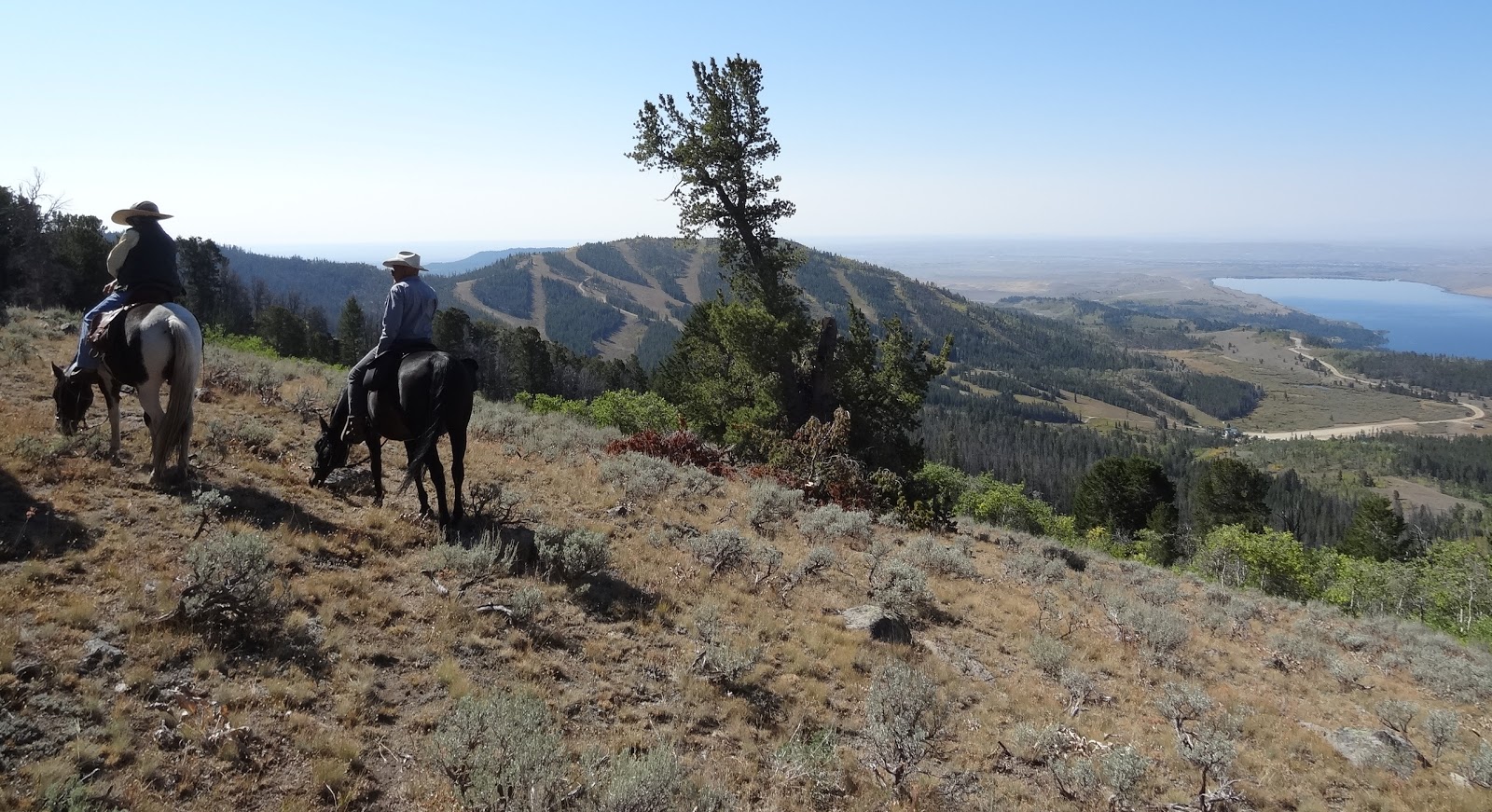
| Stunning view of the ski resort and Fremont and Soda Lakes |

 |
This is looking at the meadow where the trail to the ridge lookout is. You go down just left of those trees in the middle of the photo where there is a fairly steep trail. Our preferred option is to take the "diagonal" trail (easily visible), then cut back across the meadow to the those trees. There is a stream crossing, then uphill to the "Look out Ridge." The photo below shows the "diagonal" trail.
 |
| This is a view coming back on the trail looking at "Wolf Meadow". At the far side among the trees is a faint trail (not visible until you get into the forest) that eventually connects with the Pole Creek Trail. There is also a trail just to the right on this photo that goes through the trees and avoids the boggy meadow. |
|

Signs below are at about 2.6 miles in. I call this "Sign Meadow" because it has the sign. .2 mile from this sign, there is a split in the trail. The blue arrow and blue diamonds go to the Fortification Mountain trail to the right. Keep to the left for Miller Lake.
 |
Tiny Lush meadow still green in September at about 3.4 miles in.
|

|
| View OF the Fortification Mountain area at about 3.5 miles in. |
 |
Cute lily pond at about 4.5 miles in. (update: As of September, the pond usually dries up.)
|
 |
| Lily Pond area. Still a nice place for a lunch break. |
 |
| Just coming out of the Lily Pond area |
 |
| Our track (blue) on August 23 showing the side trails to the viewpoints and to the connector trail to Pole Creek trail. The yellow track shows the "regular" trail. |
 |
| Photo courtesy of Nancy Stephens showing just a couple of the burled trees in an amazing burl grove! |
 |
| One of the water crossings with rock ledges at approximately 4 miles in. This one's a "doozy". See the photo below for alternate. |
 |
| About 10 yards LEFT (or RIGHT coming back) of the Doozy crossing above, there is a waaaaay better one where the horses can just step over a foot wide ditch. |
 |
| This is what the entrance to the alternate trail looks like on the way back. Watch carefully, it's easy to miss. |
 |
| This is one entrance to the alternate trail on the way back. It's an obvious trail going right just after this big rock formation. |
 |
| Track of our ride on September 5, 2018, 12 miles total, Trail conditions: 65% soft dirt/grass 10% extremely rocky, 25% moderately rocky. Several small stream crossings, two of them very rocky. |
Yes, it's true. I have named the meadows in this area, because, well apparently it hadn't been done.
WHITE=
Elkhart Park Meadow
RED=Faler
Creek Meadow (along the Pole Creek Trail)
ORANGE=Look
Out Meadow (the one you go down to access the Lookout Ridge)
YELLOW=Wolf
Meadows (because that's where we saw wolves)
DARK
BLUE=Ridge Connector Meadow (that's where the Lookout Ridge connector trail
comes in)
GRAY=Burl
Meadow (just before the burl forest)
LIME
GREEN=Sign Meadow (where the sign is and the trails separate to White Pine)
LIGHT
BLUE=Spring (Camera) Meadow. Further down at the bottom is "Camera Creek".
PINK=Narrow Elk Meadow (where Fortification Mtn Trail begins)


No comments:
Post a Comment